Monthly Archives: February 2012
You Can’t Show an Old Dog Really Old Hoodoos Or, “Ode to Mr. Hightower”
Wednesday, February 15, 2012 – Allie Canyon, Mimbres Valley
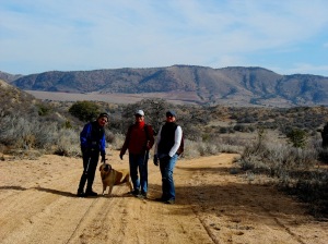
Weather and “Love Your Library Day” caused a 10-day break from hiking, but today Lynn, Julian and I hiked up Allie Canyon and checked out the hoodoos that Julian told me about. I had no idea it would be such an eventful day!
Parking near cattle corrals and a wind mill was a visual reminder that there are working ranches here in the Mimbres Valley. We geared up and headed west through lovely pine groves, a few meadows, and crossed the stream numerous times. The trail meanders up and down a few hills until several miles up the canyon we arrive at a charming camp site with a fire pit and wood logs in a circle. One of the large logs was actually cut to look like a couch with arms and a back and all! Julian mentioned that last week when he was here, he met a group resting who were with horses and enjoying the day.
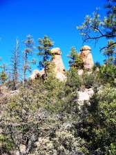
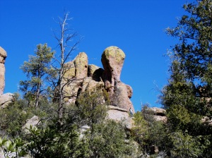
After a short rest, we continued on and were quickly rewarded with the hoodoos high above us on the right. Wow! One minute you’re walking along a forest path and the next moment, you have this awesome geological wonder!
Julian told us about a grave site nearby and Lynn found the marker. Back in 1917 Mr. Hightower died and was buried out in this remote area. I have feelers out trying to find out more about him.
************************************************************************************************************
Update: According to Levi Hill through Facebook, here is some information on Mr. Hightower:
Pedigree chart of Margery Hightower Keeling, 1017 Luck St, Silver City, NM 88061; Also, LDS FGS Eddene got about 1972.
John Carrol Hightower and Rebecca Norris had the following children:
+2 i. George Washington Hightower, born on 30 Jan 1859, Palo Pinto, Palo Pinto, TX; married Armenthia Elizabeth Adkisson, on 6 Apr 1887, Lincoln, Lincoln, NM; died on 10 Nov 1917, Fierro, Grant, NM. From this source: http://archiver.rootsweb.ancestry.com/th/read/HIGHTOWER/2008-03/1205974049
I have more of the story! On Levi’s info, I looked up the name on the Grant County Clerk’s website, and found Robert Hightower and then I found a phone #. So I called and spoke to Mrs. Hightower who lives here in Silver City. That is the marker of Robert’s grandfather. George (grandpa) and his brothers would go up Allie Canyon and spend the summer raising goats up where we saw the marker. There was a cabin in the vicinity too. Mr. Hightower got smallpox and died there. They buried him and burned down the cabin.
************************************************************************************************************
Through the trees, about 100 yards from the marker, I saw a pile of rocks and Julian and I set out to explore – it wasn’t a wall, and it was overkill for a cairn. As we approached we saw that there was a gallon jar on top with ashes in it. Another grave? A monument? A mystery!
We make our way to the base and start climbing up. In order to climb up to the hoodoos, we have to climb among trees and over boulders and between rocks. About halfway up, Cody slips down the face of a boulder in an attempt to move upward, she’s okay but I’m worried. Her backend has gotten weaker in the past few years and I’m concerned she’ll get hurt. A few more climbs up rocks and few more struggles. I call to Julian that we’re going to stay where we are. About 15 minutes later, Julian, that gallant gentleman that he is, comes down and stays with Cody and suggests I go up and check out the top. I thank him and head up, hearing a dog barking the entire ascent. The old girl really likes for me to be close by.
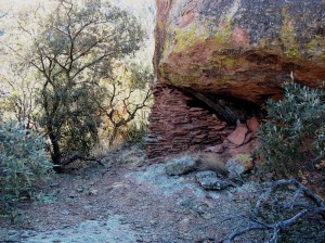
I am rewarded with amazing geological wonders. Hoodoos, some close to 60 feet high! Lynn points out views and some of the more interesting formations. Then she points out the Indian Ruin. Now I just LOVE Indian ruins and my favorite thing to do is to touch the wall. When I do this, I think about the person who placed that wall there and how they lived. I find it amazing and truly a connection to history. This one is placed at the base of a hoodoo; most of the walls are the natural stone with the front of the room being man-made with rocks. I duck inside and just sit. It’s quiet and calm. The wind is blowing outside but the air is still inside. I bet with several people inside, their body heat would make it nice and warm.
Eventually, we make our way down to ‘base camp’ (hey, I’ll use any term that makes me sound like I actually have a clue!) and rest with Julian and the dogs. And now the trek back to the car. I guess it’s true that when you turn a horse back towards the barn, they b-line for it, because what took us 3.5 hours to get to, took us 2 hours to get back from! But not before Orfa tried unsuccessfully, to talk Mom and Dad into letting her take several bones home with her and 2 encounters of the cattle kind.
5.50 miles / 5.5 hours
40 down / 60 to go
That’s what I’m talking about!
Sunday, February 5, 2012 – Burro Mountains FR 40890
Wow- the conversations that happen when 4 women get hiking together! And when you’re fired up talking, you tend to walk faster! I think politicians’ should have to hike together – I’m positively convinced that most problems could be solved during them – I know we certainly solved a lot of problems today!!
We went just under 5 miles in 2 hours and 20 minutes where in the previous hike I did less than 2 miles in 2 hours. Flat terrain is part of that but – whoa – these girls had me moving today! Now I can go enjoy the super bowl party without guilt! Go Giants!
We drove out to Mangus Valley Rd, to Red Rock Road, to T Bar T (aka T-T) and parked near FR 40890. We walked the arroyoroad (is that a word?) and enjoyed a more desert-like terrain. Sandy, low brush and rocks. We were sure to bundle up since it was cold and windy! This is the northern part of the Burros Mountain, called the Little Burro Mountains.
Here is some info from Wikipedia: The Little Burro Mountains are only a 15 mi long range. It has a northwest by southeast ridgeline, and is attached to the Big Burro Mountains that trend in the same direction. The small valley between contains Mangas Valley Road which connects Oak Grove on State Road 90 with Mangas Springs which lies on the northeast perimeter of the Big Burro Mountains. Mangas Creek and its confluence with the lengthy Gila River that completely crosses Arizona is adjacent just northwest.
4.94 miles / 2:20 hours
39 down / 61 to go
Good dog!
Thursday, February 2, 2012 – Behind Dos Griegos II and into Pinos Altos Estates
When a young visiting dog needs to stretch her legs and two old dogs don’t/won’t play, it’s time for hike #38. Our guest, the lovely Orfa, is visiting for a few days while her parents hit a Chili cook-off in Miami. So the five of us head off from the house towards the path that winds around Dos Griegos II and into the Pinos Altos Estates Sub-division. It’s all north of Silver City.
It’s a chilly, windy day so I’m glad we wore layers, gloves and ear muffs. We originally were heading towards Cleveland Mine Road. I planned to show Frank the Mine remains and reclamation area. When we got to a “T” in the trail, we decided to head upwards and check out the Pinos Altos subdivision instead. The mine will wait until another day.
The dogs behaved magnificently, staying nearby and coming when called. Orfa was a show-off when she went into a culvert and came out the other side. My dogs looked into the culvert and backed off.
I also decided it’s time to check the GPS for accuracy since we both felt like we walked further than it showed. May be time to read a manual……………………..
1.90 miles / 2:15 hours
38 down / 62 to go


