Category Archives: Butterfield Trail
March 2014 – Table Mountain Trail – City of Rocks
Now don’t be jealous, fellow trekkers, but this lucky hiker got to spend a sunny winter day with Marc Levesque hiking a stellar trail, hearing stories about adventures in Maine, New Hampshire and Antarctica, and listening to firsthand accounts of local area search and rescue missions.
Marc and his wife, Susan Porter, have been exploring the trails in this area since they moved here in 2005, and have been avid hikers for over 40 years, mostly in the mountains of northern New England. Marc was a member of the Appalachian Mountain Club, where he was involved in winter ascents, rock climbing, leading hikes and directing the AMC Mountain Leadership School in 1979-1980. Here in Silver City, he is a battalion chief with the Pinos Altos Volunteer Fire Rescue, teaches “Fundamentals of Search and Rescue” at WNMU’s Outdoor Program, and is president of Grant County Search and Rescue. Was I a little intimidated hiking with the president of Search and Rescue? Sure was. Did I have a ball hiking with him? You bet I did!
He suggested we hike a newly created trail that he described as “a gem.”
Name: Table Mountain Trail, City of Rocks State Park
Distance: 2.0-6.0 miles
Difficulty: 70% easy, 20% medium, 10% difficult
Directions: Starting from the intersection of 32nd Street By-Pass and Hwy. 180 in Silver City, drive 24.8 miles southeast on Hwy. 180 until you reach Hwy. 61. Turn left onto Hwy. 61 and drive 3.0 miles to the entrance of City of Rocks State Park.
Hike description: I suggest you stop into the Visitors’ Center and check out the history and geology of this wonderful park. Be sure to chat with park volunteers, who are extremely knowledgeable, helpful and pleasant. They have a map of the park that will assist you. Here is more info about the park for those of you who want to do some homework before you go: www.emnrd.state.nm.us/SPD/cityofrocksstatepark.html.
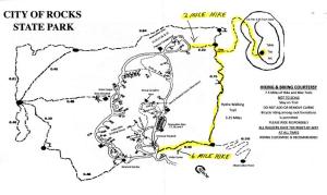
For a shorter hike, park in the northeast corner of the park near the Pegasus Campground. Walk 0.22 miles on the trail that heads east. Turn right (south) onto Hydra Trail and then turn left (east) onto the trail that takes you up to Table Top Mountain.
For a longer hike, park at the Visitors’ Center Parking lot and take the Hydra Walking Trail for 1.0 mile. Turn right (east) onto the trail that heads up to Table Top Mountain.
When you go through the gate, the trail starts the ascent uphill toward the first bench of the mountain. It gets steeper still until you finally reach the top. Look down and see the 557 feet you just climbed. Now walk around the mesa top, have fun boulder jumping, and enjoy the scenery. Return the way you came.
Notes: This is a newer trail that volunteer Tim Davis has been working on for the past few years. We met Tim on the trail; perhaps you will, too! City of Rocks State Park requires an entrance fee of $5 per car. Gates are open from 7 a.m. to 9 p.m. Why not bring a lunch and spend the day? Enjoy this trail in the morning, check out the rocks in the early afternoon, and then head over to Faywood Hot Springs for a soak to end the day just right! Or bring camping gear and explore for several days.
Tell us about a particularly memorable hiking experience:
“I was 34 years old and had just returned from a contract job at South Pole Station in Antarctica, where we had set a temperature record during the year I was there of minus-117 degrees,” says Levesque. “I had lost 22 pounds during that time and had virtually no body fat. Upon returning, I decided to get out and enjoy the White Mountains of New Hampshire on a solo day hike in 20-degree February weather. My body had not adjusted to the loss of body fat, and when I reached a spot just below the summit, I realized I was deeply shivering. I knew this was the first stage of hypothermia and probably should have turned back. But sometimes one’s testosterone level exceeds one’s intelligence quotient, so I just stopped, ate something, put on all the clothes I had with me, and continued on towards the summit.
“It all turned out okay, but between the clouds, the wind, the deep snow and the temperature, I could have easily found myself in serious trouble.” The rescuer in him comes out as he adds, “It’s really not a great idea to hike alone in such winter conditions.”
In closing, Levesque has a final comment: “Always let someone know where you’re going on a hike. It will make it much easier for us to find you if you get lost or injured.”
For more information about Grant County Search and Rescue, go to: gcsar-nm.org.
This is a repost of an article that originally appeared in Desert Exposure.
Check them out at: http://www.desertexposure.com/100hikes/
A Hike Through The Ages
04-06-12 – Pony Hill and Fort Cummings
Let me describe how I determined this hike. I asked Bob Pelham for his suggestions, and Bob is the kind of guy you want to ask since his boots have touched more New Mexico rocks than anyone I know. I suggest his hike to a friend who tells another friend where we’re going. The second friend mentions another nearby location ‘you don’t want to miss while you’re in the area’. And that is how a wonderful hiking adventure begins in the southwest part of New Mexico.
We head south towards Deming, New Mexico to find Petroglyphs and Fort Cummings. The day truly feels like a hike through time as we first find Petroglyphs aged 750-1100 years old. We drive up Green Leaf Mine Road off of Highway 26. There is a variety of mining evidence visible along the way. That’s an adventure for another day. We continue on with Helen recalling the verbal directions given to her. As described, we come to a second man-made damn and look for the parking lot, which we find easily. There is a kind gentleman (or should I call him a Petroglyphs Hunter) there who points us in the right direction. We gear up and head out. We soon find a rocky hill and start looking around at the boulders. Helen calls out that she’s found Petroglyphs and what follows is a wild period of pointing out drawings to each other – a mesmerizing hunt which the man we met in the parking lot soon joins. We have found the bulk of the Petroglyphs he has researched and hoped to find and we spend time photographing and talking and just being fascinated.

The footprint on the right is from my walking stick and the one on the right is someone else's footprint!

As I commonly do, at one point, I touch one of the shapes and close my eyes and try to imagine the person who made the drawing and their life. I did it at the Coliseum in Rome, at the Gila Cliff Dwellings, in a Mosque in southern Spain and now here on Pony Hill in New Mexico. I can’t begin to comprehend their difficulties and struggles.
Our new friend, Bill, took us a few hundred yards away and showed us the Petroglyphs he had found earlier. When we got there, we saw two other men who turned out to be the caretaker of the area and his friend. We spoke a few minutes and the caretaker asked if we had seen the macaw. He took us to the area and we saw many more drawings. Eventually, we had to move on since Fort Cummings awaited us. We exchanged email addresses with Bill, promising to share photographs, and ultimately moved on.
We have two sets of directions for Fort Cummings, one from a website and one from a map. We head off and after some dirt road driving, come to a sign that says Hyatt Ranch and sure enough, on the map, right near Ft. Cummings, it has the words, Hyatt Ranch. Okay, we’re in the right vicinity. We head off and soon run into who must be Mrs. Hyatt, who we speak to and she gives her permission for us to reach Ft. Cummings through her ranch gate. Off we go, calling “thank you” behind us. The adventure that begins here is of Thelma and Louise legend. Mrs. Hyatt tells us to go through the gate and go two miles and we’ll be at Ft. Cummings. She also tells us that her road is better than the road we missed, so we can come back through this way on our way out. Sounds easy enough? Either Mrs. Hyatt has not been on her roads for a very long time, or we’re the idiots we think we are. We head out and very soon hit a fork. We pick one and soon find another fork, and another. Mrs. Hyatt, you didn’t mention any of this. We see a newer road that was recently cut and speculate that perhaps this is the way. We climb up this road; I get out and move large rocks out of the SUV’s path. We make it to the top and although the views are SPECTACULAR, there is no sign of a fort. We wind back down, risking our very lives several times (okay, perhaps all the chocolate I ate has me exaggerating a bit…..) and decide to go back towards the beginning of our directions and start over. FINALLY, we find the right road and presently Ft. Cummings appears to our left.
Here is a short overview of the history of Fort Cummings:
http://www.legendsofamerica.com/nm-fortcummings.html
We enjoy exploring the area and reading the descriptions scattered around the area. It’s fascinating and a walk in history back about 150 years. This area of the country may look desolate but it certainly had a lot of humans living here in the past 1000 years!
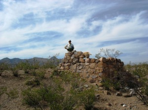
There are a variety of building foundations, parts of walls, the very important water building and a cemetery that we investigate. Looking at Fort Cummings photos on the internet, I see that it has deteriorated much in a short time.
Deming may be missing an opportunity to have people see this whole area. I can only imagine what some of the side roads hold. As I put some of photographs on Facebook, I’m already getting feedback on other sites in the area, Frying Pan Canyon being one of them. Now doesn’t that name just scream “Wild, Wild West???”
2.49 miles / 7.0 hours
53 down / 47 to go


